
How transport projects can improve housing affordability and urban productivity
11 July 2025

As our cities grapple with housing affordability and economic productivity, transport infrastructure can be part of the solution — but only if we plan land use and transport together.
At VLC, we’ve been exploring this through modelling approach for the 2025 Australasian Transport Research Forum (ATRF) Conference in Auckland. Our paper describes Spatial, our simplified quantitative spatial model (QSM) that captures how transport projects reshape where people live and work — and what that means for housing costs and productivity.
Why land use–transport feedback matters
Traditional transport models often only look at transport impacts: they estimate how many people will use a new rail line or road, but not how it will change where people live, where firms locate, or how land values shift. This “partial equilibrium” approach misses the broader economic and social impacts of transport investments. Transport really does impact land use – and vice versa – not accounting for this intimate connection is getting less defensible in how we model and plan as the stakes get higher with rising congestion, affordability, environmental impacts, and declining productivity.

The Spatial QMS addresses this by integrating land use and transport in a feedback loop. It models how improved accessibility affects commuting patterns, residential and commercial rents, and ultimately, the attractiveness of different locations for households and firms. This allows us to estimate changes in population, employment, housing affordability, and productivity — all in response to a transport shock (i.e. a transport project or a transport policy).
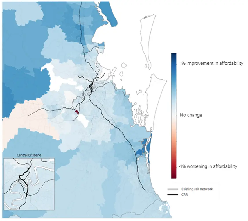
What we found: the case of Cross River Rail
We applied the model to Brisbane’s Cross River Rail (CRR) project, using our Zenith strategic transport model to simulate accessibility changes. We then ran three scenarios:
- Standard: No land use policy changes.
- Upzoned: Increased residential density allowed in areas that gain improved accessibility resulting from CRR.
- Capped: Development constrained in those same areas.
The results were striking:
| City wide results: | Housing Affordability (↑ is better) | Productivity (↑ is better) |
| Standard |
+0.31% |
+0.28% |
| Upzoned |
+0.33% |
+0.28% |
| Capped |
+0.28% |
+0.24% |
In short: transport projects like CRR can improve housing affordability and productivity — but the benefits are maximised when land use planning allows people and firms to respond to improved accessibility.
Upzoning around new stations led to greater affordability gains, while capping development reduced both affordability and productivity outcomes.
Policy takeaways
This work reinforces a simple but powerful message: transport and land use are two sides of the same coin. If we want to get the most out of our infrastructure investments — socially, economically, and environmentally — we need to plan them together.
Furthermore, if we want to maximise the benefits of transport improvements, allowing (and encouraging) development in areas that benefit from improved access can deliver a multiplier on good outcomes.
Spatial, our QSM provides a practical tool for doing just that. It can be integrated with almost any existing strategic transport model to provide a more complete picture of project impacts, helping planners and policymakers make better-informed decisions and stronger business cases for their projects.
Contact us for more information and for a copy of the upcoming ATRF 2025 conference paper which goes into more detail on the approach and the results.